When you first arrive in Perth, locals will ask a simple question: “Are you north or south of the river?” It sounds like a casual geography question until you realise it shapes everything, from house hunting to dinner recommendations to social circles. This guide unpacks both the informal cultural geography and the formal structure of Perth’s regions, so you can navigate like an insider. See here for a granular intro to all of Perth’s suburbs.
The River Divide: NOR and SOR
Perth’s most distinctive social shorthand runs along the Swan River. North of the River (NOR) and South of the River (SOR) are almost cultural identities where the river acts as a genuine psychological barrier. Locals treat crossing to the other side like a minor expedition, and it shapes everything from beach preferences to where people socialise.
This is well-established social geography and worth understanding. After six months here, you’ll likely be fiercely loyal to your side.
North of the River (NOR)
NOR stretches from Perth CBD north to Joondalup and beyond to Yanchep and Two Rocks. This region includes some of Perth’s most sought-after beaches, strong British expat communities, and established suburban wealth.
Key areas:
- Northern beaches: Scarborough, Trigg, Sorrento, Hillarys, Duncraig, Leighton. Home to Hillarys Boat Harbour, Perth’s premier waterfront precinct.
- The Golden Triangle: Cottesloe, Peppermint Grove, Nedlands, Dalkeith, Claremont. Perth’s old money heartland, bounded by the CBD, Indian Ocean, and Swan River. You’ll notice the hedges here are substantial. Locals call this area the Western Suburbs.
- Joondalup and Wanneroo: Major growth corridor with family suburbs, retail, and attractions like AQWA (Aquarium of Western Australia).
- Swan Valley: Wine and food destination 25km north-east, perfect for a day trip along the Swan River.
South of the River (SOR)
SOR runs from South Perth through the inner southern suburbs, then extends to the outer ring through Rockingham and Mandurah. It’s genuinely diverse, from affluent riverside pockets to working-class family suburbs and industrial areas.
Key areas:
- Inner south: South Perth, Applecross, Como, Booragoon. Affluent, tree-lined, river views. South Perth Foreshore is a major community hub.
- Fremantle (Freo): 19km south-west of the CBD, Freo considers itself its own entity. It’s SOR geographically but culturally distinct, with bohemian character, maritime heritage, the Cappuccino Strip, and Fremantle Markets. Note: locals always say “Freo”, never “Fremantle” in conversation. If you say Fremantle, people quietly note you’re new to town.
- Canning Vale, Gosnells, Thornlie: Family suburbs, more working-class character, but increasingly diverse and vibrant.
- Rockingham and Mandurah: Far outer SOR, 45km south. Rockingham Beach and Mandurah Estuary are major weekend destinations.
Informal Named Regions
Beyond NOR and SOR, Perth has several distinct informal regions that locals reference constantly:
The Golden Triangle
The most prestigious pocket in Perth, bounded by the CBD, Indian Ocean, and Swan River. Cottesloe, Peppermint Grove, Nedlands, Dalkeith, and Claremont are home to Perth’s old money, prestigious schools, and heritage architecture. It’s a quiet, private kind of wealth with enormous hedges.
Freo (Fremantle)
Perth’s creative, multicultural heart. 19km south-west of the CBD, Freo is a port city with its own distinct identity. Check out WA Maritime Museum, Shipwrecks Museum, Victorian architecture, and the buzzing Cappuccino Strip.
The Hills
Darling Scarp communities 30-50km east of Perth, including Kalamunda, Mundaring, and Roleystone. These have a strong separate identity, cooler temperatures, bushland lifestyle, and are popular for weekend escapes and hiking. Home to attractions like Serpentine Falls and a great base for exploring Reabold Hill.
Northbridge
Perth’s entertainment, dining, and nightlife district immediately north of the CBD along William Street. Home to the Cultural Centre including WA Museum Boola Bardip and Art Gallery of WA.
Swan Valley
Wine and food valley 25km north-east of Perth along the Swan River. Popular day-trip destination in the City of Swan LGA. Home to Whiteman Park, one of Perth’s great free family destinations.
Perth’s Formal Regional Structure: Local Government Areas
Administratively, greater Perth (the Perth Metropolitan Region under the Planning and Development Act 2005) is divided into 5 formal subregions managed across 30 Local Government Areas (LGAs): 20 cities, 3 shires, and 7 towns. This formal structure handles planning, services, and local governance.
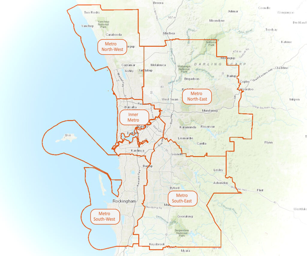
The 5 Metropolitan Subregions
1. Inner Metro Area (19 LGAs)
The city core and established inner suburbs. Includes City of Perth (the CBD proper), Fremantle, major shopping centres, and close-in communities.
2. North-eastern Outer Metro (3 LGAs)
The Hills region and Swan Valley: City of Kalamunda, City of Swan, Shire of Mundaring.
3. North-western Outer Metro (2 LGAs)
Northern growth corridor: City of Joondalup, City of Wanneroo.
4. South-eastern Outer Metro (3 LGAs)
Outer south-east suburbs: City of Armadale, City of Gosnells, Shire of Serpentine-Jarrahdale.
5. South-western Outer Metro (3 LGAs)
Outer south coast: City of Cockburn, City of Kwinana, City of Rockingham.
Local Government Area Reference Table
Here’s a quick reference for Perth’s 30 metropolitan LGAs, organised by subregion:
| LGA | Type | Subregion | Key Notes |
|---|---|---|---|
| City of Perth | City | Inner Metro | CBD proper. 14 km², pop. 30,364 |
| City of Fremantle | City | Inner Metro | Freo. 19 km², pop. 33,711 |
| City of Stirling | City | Inner Metro / NOR | Perth’s most populous LGA. 105 km², pop. 235,845. Scarborough and Trigg beaches. |
| City of Wanneroo | City | North-western Outer | Northern growth corridor. 683 km², pop. 220,932 |
| City of Joondalup | City | North-western Outer | 99 km², pop. 165,512. Hillarys Boat Harbour, AQWA. |
| City of Swan | City | North-eastern Outer | Swan Valley, Whiteman Park. 1,043 km², pop. 163,699 |
| City of Kalamunda | City | North-eastern Outer | The Hills. 324 km², pop. 61,229 |
| Shire of Mundaring | Shire | North-eastern Outer | The Hills. Mundaring Weir, John Forrest NP. |
| City of South Perth | City | Inner Metro | Inner SOR, river frontage. 19.8 km², pop. 45,106. Perth Zoo, foreshore. |
| City of Subiaco | City | Inner Metro | Most liveable LGA in Australia (2023 Liveability Census). 5.6 km², pop. 17,967 |
| Town of Cottesloe | Town | Inner Metro | Golden Triangle. Cottesloe Beach. 3.9 km², pop. 8,297 |
| Shire of Peppermint Grove | Shire | Inner Metro | Golden Triangle. One of Australia’s smallest LGAs. |
| City of Melville | City | Inner Metro | Affluent inner SOR. Applecross, Booragoon. 53 km², pop. 107,311 |
| City of Canning | City | Inner Metro | Middle-ring SOR. Cannington, Bentley, Wilson. |
| City of Nedlands | City | Inner Metro | Golden Triangle. UWA campus, Matilda Bay. |
| City of Bayswater | City | Inner Metro | Inner NOR middle suburbs. |
| City of Belmont | City | Inner Metro | Perth Airport is within City of Belmont and City of Swan. |
| City of Vincent | City | Inner Metro | Northbridge, Leederville, Mt Lawley. Inner city dining and culture. |
| Town of Cambridge | Town | Inner Metro | Floreat, City Beach. Adjoins Bold Park. |
| Town of Claremont | Town | Inner Metro | Inner Golden Triangle. Shopping strip, café culture. |
| Town of Mosman Park | Town | Inner Metro | Golden Triangle coastal suburb. |
| Town of East Fremantle | Town | Inner Metro | Riverside heritage suburb adjacent to Freo. |
| Town of Bassendean | Town | Inner Metro | Inner eastern riverfront community. |
| Town of Victoria Park | Town | Inner Metro | Albany Highway dining strip. Inner SOR, close to CBD. |
| City of Rockingham | City | South-western Outer | 45km south. 258 km², pop. 143,560. Rockingham Beach, Penguin Island. |
| City of Kwinana | City | South-western Outer | Industrial and residential south corridor. |
| City of Cockburn | City | South-western Outer | Southern coastal corridor. Coogee, Spearwood. |
| City of Armadale | City | South-eastern Outer | South-eastern regional centre. Gateway to The Hills. 560 km², pop. 100,737 |
| City of Gosnells | City | South-eastern Outer | Outer south-eastern family corridor. 127 km², pop. 132,845 |
| Shire of Serpentine-Jarrahdale | Shire | South-eastern Outer | Peel gateway. Rural and semi-rural fringe. |
Noongar Country and Indigenous Context
Perth sits on Wadjuk Noongar Country. The Swan River and surrounding landscape carry deep Indigenous history and living cultural significance. Many modern suburb names have Noongar origins, and Indigenous place names are increasingly used in signage, tourism, and everyday reference. Rottnest Island, for example, carries the Noongar name Wadjemup. As you explore Perth, you’ll encounter Noongar language and Country acknowledgements across museums, parks, and cultural spaces, particularly at the WA Museum and throughout Fremantle.
Getting Around: Distance and Travel Times
Perth is a genuinely spread-out city. Greater Perth spans roughly 120km north to south, so realistic travel times matter:
- CBD to Fremantle (Freo): 19km, 20-30 minutes by car or 30 minutes by train
- CBD to Rockingham: 45km, 45-60 minutes by car
- CBD to Kalamunda (The Hills): 30km, 35-45 minutes by car
- CBD to Joondalup: 25km, 30-40 minutes by car or 55 minutes by train
- CBD to Yanchep: 50km, 50-60 minutes by car
- CBD to Mandurah: 72km, 60-75 minutes by car or 75 minutes by train
Public transport is available via Perth’s Transperth train, bus, and ferry network. For exploring beyond the inner city and day trips, having a car is a genuine advantage.
Frequently Asked Questions
What does NOR and SOR mean in Perth?
NOR stands for North of the River and SOR for South of the River, referring to the Swan River. These are the main cultural and social divisions in Perth, shaping where people live, socialise, and travel. It’s real social shorthand, though not an official administrative boundary.
What is the difference between the City of Perth LGA and greater Perth?
The City of Perth LGA is only 14 km² and covers the CBD proper with a population of about 30,000. Greater Perth (the Perth Metropolitan Region) spans 30 LGAs and over 2 million residents across approximately 120km north to south. When people say “Perth”, they almost always mean greater Perth, not just the CBD LGA.
How many suburbs are there in Perth?
Perth has over 300 suburbs distributed across 30 Local Government Areas. The exact count shifts as suburb names change and boundaries adjust, but it’s a genuinely large and sprawling city.
What is the Golden Triangle in Perth?
The Golden Triangle is Perth’s most prestigious inner-west pocket, bounded by the CBD, Indian Ocean, and Swan River. It includes Cottesloe, Peppermint Grove, Nedlands, Dalkeith, and Claremont. Locals often call it simply the Western Suburbs.
Is Fremantle north or south of the river?
Fremantle (Freo) is geographically south of the river, but it considers itself its own entity. It has a distinct bohemian, port-city identity separate from broader SOR. It’s a 20-30 minute drive or train ride from the CBD and very much worth a dedicated visit.
Where is The Hills in Perth?
The Hills refers to communities along the Darling Scarp, 30-50km east of Perth. The main areas are Kalamunda, Mundaring, and Roleystone. They’re cooler, more bushland-focused, and popular for weekend escapes and walks. Serpentine Falls is one of the Hills’ best-known natural attractions.
What suburbs are considered affluent in Perth?
The Golden Triangle (Cottesloe, Peppermint Grove, Dalkeith, Nedlands, Claremont) represents Perth’s historic prestige corridor. Inner SOR suburbs like Applecross, Como, and South Perth are also highly regarded. Subiaco was ranked the most liveable LGA in Australia in 2023. However, Perth’s property market is diverse and suburbs have changed significantly over recent decades.
References
- 2023, Regional population, 2021-22 financial year – Australian Bureau of Statistics, abs.gov.au/census/find-census-data/quickstats/2021/5
- 2025, PlanWA, Department of Planning, Lands and Heritage, planning.wa.gov.au/mapping-and-data/planwa