

Stand at Serpentine Falls, roughly 55km southeast of the Perth CBD, and it’s hard to believe you’re still within the metropolitan region. Water drops around 15 metres into a rock-rimmed pool, jarrah forest closes in on both sides, and the traffic noise from Perth has long since disappeared. This is the Perth Hills, the foothill and escarpment country of the Darling Range that starts roughly 25 to 30 minutes east of the city and runs through towns like Kalamunda, Mundaring, Roleystone and Bickley, and it’s the closest bush escape most Perth visitors never think to take.
The Perth Hills isn’t one destination but a loose region featuring a scattering of waterfalls, national parks, wineries, orchards and small towns spread across the Darling Range on Traditional Noongar Country. Kalamunda is the practical hub, with the most cafes and services, but Mundaring, Roleystone and Bickley each have a distinct character worth knowing before you plan a day.
Who It Suits
Families and casual walkers wanting a half-day escape without a long drive, wildflower and wildlife enthusiasts visiting in spring, and anyone building a Perth itinerary who wants bushland rather than a manicured park. It’s a poor fit if you’re chasing dramatic, high-volume waterfalls year-round; most of the region’s falls are seasonal and rely on winter rain, running thin or dry over summer.
Waterfalls: What’s Actually There
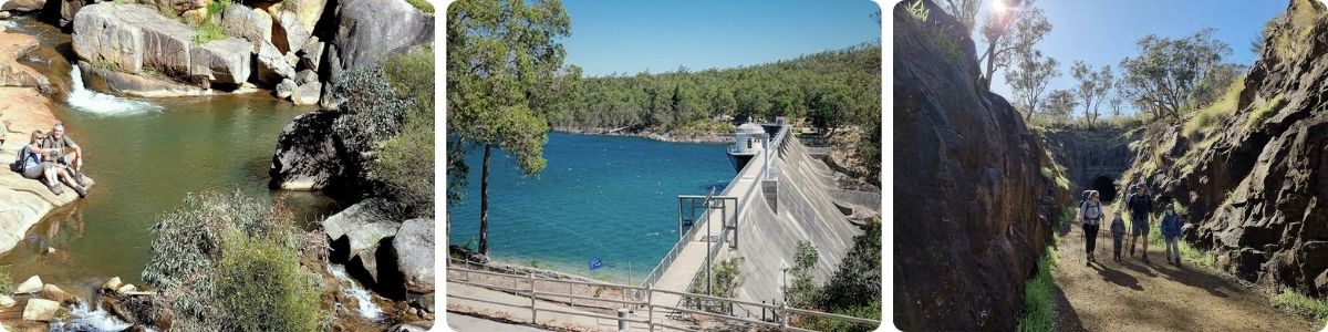
Lesmurdie Falls, the region’s most accessible, drops around 50 metres and has a network of official DBCA trails ranging from a short 640-metre, 30-minute walk to a longer 3km loop; it’s the best starting point for a first visit and gets busy on weekends as a result. Serpentine Falls, in Serpentine National Park about 55km from the CBD, is a shorter but still worthwhile stop: the falls drop roughly 15 metres, and the official Falls Walk Trail is an easy, well-formed 400-metre walk to the viewing platform, considerably gentler than the steep descent some older guides describe. Piesse Brook, in Kalamunda National Park, follows a section of the Bibbulmun Track past glistening granite boulders and smaller cascades and is a quieter alternative if Lesmurdie’s car park is full.
All of these are seasonal. Flow is strongest from winter through early spring (roughly June to September) after rain; by late summer, several of the smaller falls can slow to a trickle or stop altogether, so if a waterfall photo is your priority, plan around the wetter months rather than midsummer.
Bushwalking and National Parks
Kalamunda National Park has an easy, family-friendly loop trail (around 2.7km) laid out on the site of the old Kalamunda Golf Course, alongside sections of the long-distance Bibbulmun Track for anyone wanting a shorter taste of a much longer walk. John Forrest National Park, Western Australia’s oldest national park, just south of Kalamunda, offers more range: a 4.6km Wildflower Walk Trail (grade 3) that’s particularly good between roughly August and November when wildflowers are out, up through a demanding 14.8km circuit with sweeping views back across the Swan Coastal Plain to the city and coast for more experienced walkers. Roleystone’s escarpment lookouts offer some of the best panoramic views in the region without requiring a full day’s walking to reach them.
Scenic Drives, Villages and Wine
The drive out along Great Eastern Highway toward Kalamunda climbs steadily through the foothills with views opening up as you gain elevation; it’s worth a stop at one of the lookout points along the way rather than driving straight through. Mundaring Weir, a historic dam with a lake and lakeside walking trails, makes a good half-day loop on its own, with a cafe overlooking the water for a coffee stop. Small, family-run wineries are scattered around the Mundaring and Bickley areas; expect modest cellar doors and regional pricing rather than Swan Valley-scale tourism infrastructure. Kalamunda’s main street has the region’s best concentration of cafes and casual eateries, useful as a base for fuelling a day of walking rather than a food destination in its own right.
Wildflowers and Farm Experiences
Spring (roughly September to November) brings wildflower displays through Kalamunda and John Forrest National Parks, including kangaroo paw, native orchids, everlastings and banksias. It’s not as famous as the Porongurups or WA’s South West wildflower routes, but the displays are real and considerably less crowded. Several properties around the hills run seasonal cherry and apple orchard experiences, typically peaking around March to April; these are working farms rather than staged tourist attractions, so expect a agricultural setting rather than a curated experience.
Getting There
Driving is by far the most practical option. Great Eastern Highway from Perth reaches Kalamunda in roughly 40 to 50 minutes depending on traffic, with free parking at the main town centres and most trailheads. Public transport is more limited than some guides suggest, and Kalamunda’s passenger railway closed back in 1949 and the town hasn’t had train service since, so despite the name recognition, there’s no “Kalamunda line” to catch today.
That said, two workable public transport routes do exist: the Airport line train to High Wycombe Station, then bus route 276 into Kalamunda Bus Station, or a more direct bus route 655 from Perth Stadium Bus Station, which reaches Kalamunda in around 40 minutes without a transfer.
Kalamunda Bus Station itself, next to the Kalamunda Central shopping centre, is served by around eight Transperth routes in total, with route 320 also connecting Midland to Mundaring for that side of the hills. Check the Transperth journey planner for current routes and frequency, since services thin out considerably outside peak times, and once in the hills, a car (or a lot of walking between trailheads) is necessary for reaching individual waterfalls and lookouts; phone reception is patchy in the bush, so download offline maps before you set out, and carry at least a litre or two of water per person on any of the longer walks.
Planning Your Day
A short escape: drive to Lesmurdie Falls (about 25 minutes from Kalamunda), walk the short Falls Trail, and head back; doable in around three hours including driving. A fuller half-day: Lesmurdie Falls, coffee in Kalamunda, then a second walk such as the Kalamunda National Park loop or a stretch of the Bibbulmun Track, wrapping up in five to six hours from the CBD and back.
A full day: Serpentine Falls in the morning, lunch in Kalamunda, then an afternoon walk at John Forrest National Park or the Roleystone escarpment lookouts, home by early evening. If you want more than a day trip, Kalamunda and Mundaring both have accommodation options, and a couple of farm stays in the region offer a more immersive overnight base, though these need booking well ahead, particularly over spring wildflower season and school holidays.
What Locals Know
Regular hills visitors know the difference between the well-known falls and the quieter alternatives, and will point first-timers toward Lesmurdie’s quieter Weir Road car park rather than the busier main Falls Road entrance on weekends. Locals also plan waterfall visits around recent rainfall rather than a fixed calendar date, since a “good” flow varies year to year depending on how wet the preceding winter has been; checking recent rainfall or a local hiking group’s photos before driving out saves a disappointing dry-falls trip. Flies and heat are the most commonly cited summer bugbears on hills walks, and locals typically shift their walking to early morning in the warmer months rather than persisting through the middle of the day.
Is It Worth It?
Yes, particularly for visitors who’ve only seen Perth’s beaches and CBD. The Perth Hills won’t rival the South West’s forests or waterfalls in scale, but the combination of bushland, real seasonal waterfalls, and small-town character within under an hour of the city is a legitimate point of difference. Time your waterfall visit around recent rain rather than a fixed season, drive rather than rely on public transport, and treat it as a half or full-day trip rather than trying to cram the whole region into a couple of hours.
Frequently Asked Questions
How far is the Perth Hills from the CBD?
Roughly 25 to 55km depending on the specific destination, with driving times from about 40 minutes (Kalamunda) up to an hour or so (Serpentine Falls).
What’s the best time to visit?
Spring (September to November) for wildflowers and generally still-flowing waterfalls, and winter (June to August) for the fullest waterfall flow, though it’s cooler and greyer. Summer is workable for early morning or evening walks but expect low or no waterfall flow.
Can I get there without a car?
It’s possible but limited. Kalamunda’s rail line closed in 1949 and hasn’t reopened, but the Airport line to High Wycombe Station plus bus route 276, or the more direct bus route 655 from Perth Stadium Bus Station, both reach Kalamunda in around 40 minutes. Coverage to individual trailheads and waterfalls beyond the town centres is limited, so a car is the realistic option for exploring the wider region.
Are the walks difficult?
Most popular short walks (Lesmurdie’s Falls Trail, Serpentine’s Falls Walk Trail, the Kalamunda National Park loop) are easy to moderate and suit most fitness levels. Longer options like John Forrest’s 14.8km circuit are demanding and better suited to experienced walkers.
Will the waterfalls definitely be flowing?
Not guaranteed. Flow depends on recent rainfall and is strongest June to September; by late summer several falls slow to a trickle or stop. Check recent conditions before driving out if seeing water is the priority.
Where should I start?
Kalamunda is the practical hub with the best concentration of cafes and services, and Lesmurdie Falls nearby is the easiest first waterfall stop for most visitors.
Parting Thoughts
The Perth Hills rewards people willing to drive 40 minutes and do a bit of walking rather than sticking to the coast. Time it around recent rain if waterfalls matter to you, bring water and a paper or offline map, and treat Kalamunda as your base rather than your only stop. The Serpentine Falls guide has more detail if that’s your first hills destination.