
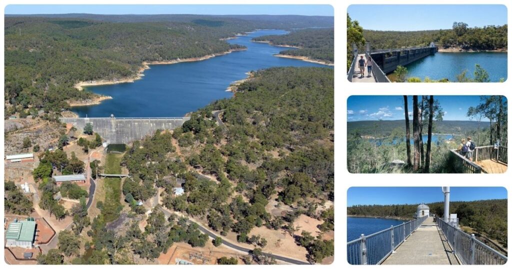
Stand at the base of Mundaring Weir, roughly 40km northeast of Perth CBD, and look up at a concrete gravity dam that once solved what seemed like an impossible problem. Mundaring Weir isn’t a place that trends on Instagram the way Kings Park does, but it’s the kind of site that explains something about Perth’s history the city centre simply can’t.
Built between 1898 and 1903 and designed by engineer C.Y. O’Connor, the weir was the starting point of a 566-kilometre gravity-fed pipeline supplying fresh water to the Eastern Goldfields towns of Coolgardie and Kalgoorlie, which had none of their own. It worked, and in modified form it still does. It’s also a site with a difficult human story behind it, one that adds another dimension to any visit.
Who It Suits
History and engineering enthusiasts who want more than a plaque and a photo, families who enjoy walking and picnicking over structured play activities, and anyone building a full Perth Hills day who wants a different kind of stop from the region’s waterfalls and national parks. It’s a poor fit if you’re after a quick, high-impact photo stop; the site rewards an hour or two of unhurried walking and reading rather than a five-minute drive-by.
The Story Behind the Dam
Gold was discovered at Coolgardie and Kalgoorlie in the early 1890s, drawing thousands of prospectors into desert country with essentially no reliable water supply. C.Y. O’Connor, an Irish-born engineer serving as WA’s Engineer-in-Chief, proposed building a dam in the Perth Hills, where water was reliable, and pumping it 566 kilometres inland via a gravity-assisted pipeline. Parliament approved the scheme in 1898, and construction went ahead through a period of sustained, often vicious public criticism, much of it driven by a newspaper campaign accusing O’Connor of corruption and mismanagement.
O’Connor didn’t live to see it succeed. Worn down by the criticism and a looming Royal Commission into the project, he took his own life in March 1902, riding his horse into the sea off South Beach, Fremantle. Less than a year later, on 24 January 1903, water reached Kalgoorlie and the scheme was formally opened by Premier Sir John Forrest, who spoke of his sadness that O’Connor hadn’t lived to receive the recognition he was owed. It’s a sobering piece of context for a site that otherwise reads as a straightforward engineering triumph, and it’s worth knowing as you walk the dam wall today.
The Weir Itself
Mundaring Weir is a concrete gravity dam, meaning it holds back water through sheer mass rather than arched geometry. Originally built to a height of 30 metres and completed in 1903 (when it was claimed to be the world’s highest overflow dam, a title long since surpassed), the wall was raised by a further 9.8 metres in 1951, bringing it to roughly 40 metres and substantially increasing the reservoir’s capacity. You can walk across the top of the dam via a pedestrian path, a straightforward, largely level 15 to 20 minute walk with good views over the Helena River valley below.
The No. 1 Pumping Station and C.Y. O’Connor Museum
At the base of the dam, the former No. 1 Pumping Station now houses the small C.Y. O’Connor Museum, volunteer-run museum covering the engineering and history of the Goldfields water scheme, including original pumping equipment, historical photographs, and maps tracing the full 566km pipeline route now known as the Golden Pipeline Heritage Trail. It’s a focused, modestly sized museum rather than a major attraction in its own right, but the volunteer staff, when present, are often knowledgeable and worth engaging with. Museum hours can vary, so treat the outdoor site and walking trails, which are always accessible, as the reliable part of your visit.
Walking Trails
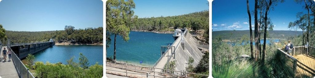
The dam-top path itself is the easiest option and arguably the best value for effort: accessible, gradual, and roughly 15 to 20 minutes for good views. You can also follow a trail from the weir, leading west that leads to the “Golden Pipeline” and the Helena River, known as the Munda Biddi trail and it provides some sensational views along route and is about 45 min one way. It connects to the Pauls Valley Trail and then the Lower Helena Diversion Dam and the Helena River Walk some 4 hours walk to the west. Another trail from the weir leads to Golden View Lookout, about 35 minutes one way, and amazing views of the weir and countryside are on offer.
Picnic Areas and Practicalities
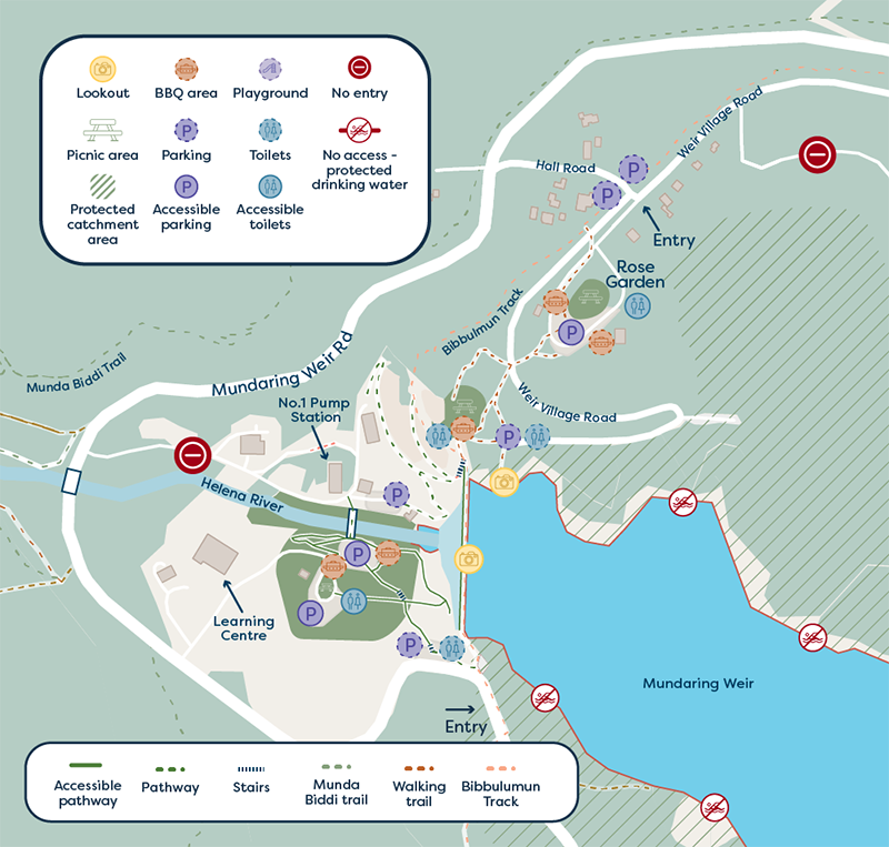
Several picnic areas offer tables, barbecue facilities, shade and toilets, and drinking water is available at the main site. There’s no food for sale at the weir itself; Mundaring township, about 2km away, has small shops and cafes if you’d rather not bring your own lunch. Swimming in the reservoir isn’t permitted, since the water still forms part of the goldfields drinking supply.
Getting There
Allow around 40 to 50 minutes’ drive from Perth CBD via Great Eastern Highway toward Mundaring, with free parking at the main site. Public transport can get you as far as Mundaring township but no further: take the Midland line train to Midland Station, then transfer to bus route 320, 321 or 322 toward Mundaring town centre via Great Eastern Highway. From there, the weir itself is still about 9km away, with no onward bus service, so you’d need a taxi, rideshare or a fair walk to cover the final stretch. Given that gap, driving is the realistic option for almost all visitors; check Transperth’s journey planner for current 320/321/322 timetables if you’re planning the train-and-bus leg regardless.
What Locals Know
Perth Hills locals treat Mundaring Weir as a deliberately quieter alternative to the region’s more crowded waterfall walks, and regulars will tell you it’s one of the least busy Perth Hills sites even during peak spring wildflower weekends. Locals also know to pair it with Mundaring township for lunch rather than relying on the weir’s limited on-site facilities, and to check the museum’s opening status before making a special trip for it specifically, since its volunteer-run hours are less predictable than the always-open outdoor site.
Combine With the Perth Hills
John Forrest National Park, a short drive south, is the natural extension for a longer Perth Hills day, with its own waterfalls and heritage rail history. Kalamunda National Park and the Kalamunda township are also within easy reach. A realistic day: depart Perth by 9am, spend an hour and a half at Mundaring Weir and the dam walk, lunch in Mundaring township, then a further walk or a stop at John Forrest National Park in the afternoon before heading back to the city.
Is It Worth It?
Yes, particularly if you want to understand Perth’s relationship to the inland goldfields rather than just its beaches and river. It’s not a flashy stop, and the museum’s variable hours mean you shouldn’t build a trip around it alone, but the dam walk and the story behind it, including O’Connor’s own tragic ending, make this a worthwhile 40-minute drive rather than a novelty detour.
Frequently Asked Questions
Is Mundaring Weir free to visit?
Yes, entry, parking, walking trails and picnic areas are all free. The museum operates on a volunteer basis with variable hours.
How long should I spend here?
Around two to three hours for the dam walk and surrounds, longer if you add nearby trails or combine with John Forrest National Park.
Can I swim in the reservoir?
No, the water still supplies the Eastern Goldfields and swimming isn’t permitted.
What’s the Golden Pipeline?
The popular name for the Goldfields Water Supply Scheme, C.Y. O’Connor’s 566km pipeline from Mundaring Weir to Kalgoorlie, now tracked as a heritage trail with multiple listed sites along its route.
Best time to visit?
Autumn (roughly March to May) for mild weather and low crowds, with spring a close second for wildflowers in the surrounding bushland.
Is it accessible for people with mobility issues?
The main dam walking path is relatively accessible, being paved and gradual. Other bushland trails vary in surface and difficulty. Picnic areas and the museum have standard accessible facilities.
How do I get there without a car?
Train to Midland Station, then bus route 320, 321 or 322 to Mundaring town centre. The weir itself is still about 9km further, with no onward bus, so you’d need a taxi or rideshare for the last leg, or accept a long walk. Driving remains the practical choice for most visitors.
The Close
Mundaring Weir isn’t a place that photographs itself the way a waterfall does, but it explains something important about how Perth and WA’s inland goldfields are connected. Walk the dam, visit the museum if it’s open, and take a moment to think about the engineer who solved the problem but didn’t live to see it succeed.